
Colorado Fly Fishing Articles
Fly Fishing Colorado's Roaring Fork River
Fly Fishing the Roaring Fork River Watershed
Overview of the Roaring Fork Drainage
The Roaring Fork watershed is located on the western side of the Continental Divide in Central Colorado. The Roaring Fork River is a tributary to the Colorado River.
Major rivers of the Roaring Fork Watershed include the Roaring Fork and its tributaries, the Crystal and Frying Pan (Fryingpan) Rivers.
Roaring Fork River
The Roaring Fork River is a freestone river which begins its 70 mile, 7000 ft. drop to the Colorado River high above Aspen in the Sawatch Range near Independence Pass (12,095 ft.) and picks up most of its volume after it passes Aspen. It joins the Colorado River at Glenwood Springs.
Upper Roaring Fork
The headwaters of the Roaring Fork, to within a few miles of Aspen, is almost all public land which allows good fly fishing access to the water at various highway pull outs and campgrounds. From the top of Independence Pass to the town of Aspen the Roaring Fork drops 4200 feet in elevation to the town of Aspen (Approx.19 miles). At this point the river is fairly fast but doesn’t contain a lot of volume.
From Aspen to Basalt the river loses gradient but also picks up volume from the surrounding mountains. The elevation drop is only about 1300 feet in the 15 miles to Basalt. Much of the river from Aspen to Basalt is designated as “Wild Trout Water” meaning that the river is capable of supporting wild trout that can complete an entire life cycle in the river and does not have to be stocked, but can be. To support this designation, there may be special fishing regulations that require fish to be quickly released into the river after being caught (See Catch and Release).
Because the river is still relatively small with lower flows this section is best fished by wading.
Middle Roaring Fork
At Basalt the Frying Pan River joins the Roaring Fork and increases in volume significantly. From this point to Glenwood Springs, a distance of 28 miles, “The Fork” has been designated as “Gold Medal Water”. Gold Medal Waters are considered the highest quality cold-water habitats. To receive the designation the water must support an average of 12 trout of 14 inches or longer and produce trout of 60 pounds per acre. Similar to “Wild Trout Water”, there may be special fishing regulations that require fish to be released into the river after being caught.
From Basalt to Glenwood Springs the Roaring Fork can be float-fished.
Lower Roaring Fork
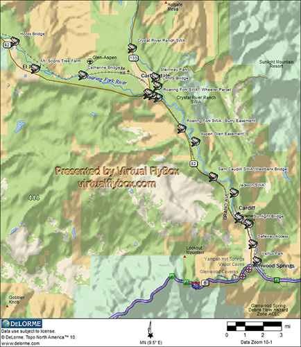
Down river in Carbondale, the Roaring Fork is joined by the Crystal River and becomes a much large river and hold some huge fish. The river carries the “Gold Medal Water” designation that began at Basalt.
This section can be wade-fished or float fished.
Frying Pan River
Moving down the Roaring Fork Valley from Aspen, the first major tributary of the Roaring Fork River is the Frying Pan River.
The Frying Pan River begins its 42 mile drop to the Colorado River high in the Hunter-Fryingpan Wilderness Area. Much of the access to water above the Ruedi Reservoir is comprised of high mountain streams that don’t receive as much pressure from the fishing community as below the reservoir, and offers opportunities to catch smaller brook, cutthroat and rainbow trout.
The Frying Pan River flows into the Ruedi Reservoir above Basalt, Colorado. The reservoir’s tailwater has become a major year-round fishery with trout growing to huge sizes as a result of the rich aquatic life (Mysis Shrimp) that the reservoir supports. Because the waters come from the bottom of the Reservoir, the water is consistently cold and provides
the fish protection from the heat of the summer and the cold of winter. Numerous hatches also provide the fish with a steady diet of insects.
“The Pan” supports numerous Brown, Rainbow, Cutthroat and some Brook trout. To fish these waters bring your waders and be prepared for crowds.
The entire distance from the reservoir’s tailwater to Basalt is designated as “Gold Medal Water”.
The Frying Pan River joins the Roaring Fork River at Basalt, Colorado.
Crystal River
This freestone river begins its 35 mile drop to the Colorado River above the towns of Crystal City and Marble, Colorado. The Crystal River begins high in the Elk Mountains, flows through the White River National Forest. Because the majority of the river flows through National Forest, there is spectacular scenery and abundant access to the river along road pull outs and camp grounds.
Some say that the river offers a more quiet fishing experience compared to the Frying Pan. Because the Crystal River is a freestone river, its clarity is impacted by snow melt, temperature and rainfall. The river can become very discolored and muddy during runoff and after rainstorms.
Although the Crystal River may not be as productive as the Roaring Fork and Frying Pan, the river still provides decent fishing opportunities. The Crystal River supports wild populations of German Brown, Rainbow, Cutthroat and Brook Trout as well as Whitefish and is also stocked with Rainbow trout.
The Crystal River joins the Roaring Fork just below Carbondale, Colorado.
_________________________
Major Towns
There are several towns along Colorado State Highway between Glenwood Springs and Aspen. A few of the larger ones include: Glenwood Springs, at the confluence of the Roaring Fork and the Colorado Rivers, Carbondale, Basalt and Aspen. All of these towns have a variety of Restaurants, Lodging and other resources for the fly fishermen.
Following are links to a few of the town’s web pages:
Also see our:
Roaring Fork Fly Fishing Resources
_________________________
Roaring Fork Valley Public Fly Fishing Access
Upper Roaring Fork Fishing Access
Headwaters
The headwaters to within a few miles of Aspen are almost all public land which allows good access to the water at various highway pull outs and campgrounds.
Rio Grande Trail Access
The Rio Grande Trail is a public trail that follows the river and provides 5.5 miles of public access on the north side of the river starting at Wilton Jaffee Sr. Park (100 McLain Flats Rd., Aspen). After exiting a scenic gorge above the park, the river becomes a series of riffles, pools, and boulder gardens. (N39° 15.4100'; W106° 52.9017'). Take the lower trail along the river.
Woody Creek Access
South side below the bridge.
Phillips Curves Access
Colorado 82 mm29 and 30.
Old Snowmass Access
Just past the Old Snowmass Conoco on Hwy. 82, turn onto Lower River Road and turn onto N. River Road. Follow the trail signs to a small parking lot. Walk down the trail a few hundred feet, past a utility building and follow the signs down the trail to the Roaring Fork River (N39° 19.9443', W106° 59.1652').
Roaring Fork Club
Drive to the clubs administration building (a log building along Highway 82 up-valley from Basalt) and locate the parking signs. Anglers have access to the one-mile stretch owned by the club. (N39° 21.2966'; W107° 1.2865')
Basalt Town Access
• From Basalt downstream along Two River Road to the Lower Bypass Bridge there is excellent public
access (look for the pullouts).
• On the bank of the Fryingpan where it meets the Roaring Fork (the downtown side).
• On the bank of the Roaring Fork just downstream from the confluence (downtown side).
• On the Fryingpan behind the Riverside Grill restaurant.
• Most of the bank across the Fryingpan from the Riverside Grill.
• From Two Rivers Road up to Swinging Bridge Lane.
• Public trail near the Ute Center condos at the confluence of the Fryingpan and Roaring Fork.
• Fisherman's Park (N39 21’37.6196; W107° 1.6252').
• Old Pond Park (N39 22’06.1; W-107 02’22.3).
Middle Roaring Fork Fishing Access
Hooks Bridge Access
Located off Willits Lane just past the Midvalley Design Center in Basalt. Hooks Bridge is to the left. Hooks contains a boat ramp, a river easement and a bridge crossing. Fishing access is from the bridge upstream for a quarter-mile on the north bank. (N39° 22.4087', W107° 5.0428')
Mt. Sopris Tree Farm Access (El Jebel)
Turn at the El Jebel intersection of Highway 82 and Valley Road. Fishing access is about 1.5 miles upstream on the north side of the river. Parking is available on the western end of the access. (N39° 23.6714', W107° 6.2926')
Catherine Bridge Access
Between Carbondale and Emma along CR100. (N39° 24.4651'; W107° 9.1467')
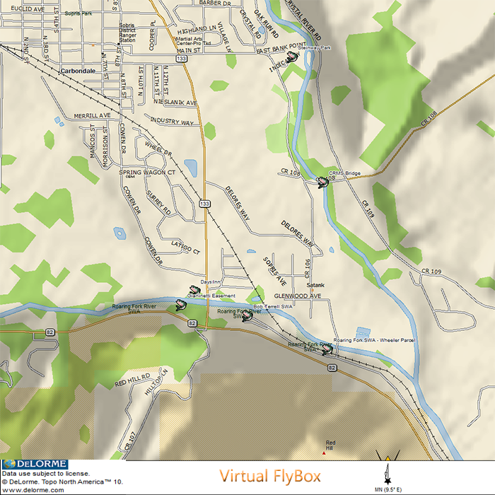
Bob Terrell SWA (Koziel, Wheeler, Dag and Gianinetti Easements)
Essentially at Hwy. 82 and 133 in Carbondale. From the intersection of Hwy. and 133, go about 1 mile down valley (toward Glenwood Springs) on Hwy. 82. Turn left onto CR 106 and follow it back toward Carbondale. Keep left at the fork in the road to stay between Hwy. 82 and the river. The road will dead ends at the parking area. (N39° 24.9221'; W107° 13.4634')
Lower Roaring Fork Fishing Access
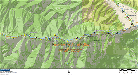
Aspen Glen Easement
From Carbondale, take Hwy. 133 to 82 and turn left. Once you pass mile marker 10, watch for a dirt-road turnoff to the left. Parking is at the waste water treatement plant. Access is from the lower boundary of Aspen Glen to the eastern boundary of BLM land, about two miles on the south bank. (N39° 27.1274'; W107° 16.1016')
Roaring Fork SWA (Burry Easement)
Turn off Hwy. 82 at the Burry Ranch (Across from Aspen Glen), park in a small parking lot, then walk down a dirt path to the river. (N39° 26.5059', W107° 15.2480')
Roaring Fork State Wildlife Area (West Bank Lease)
This SWA is a drift boat launching site and parking area located on the Roaring Fork River located below the bridge at Carbondale. There is a short stretch of the river on the property for wading or fishing from the bank. Access is on the first gravel road north on Hwy. 82.
Westbank / Sam Caudill SWA
Drive up-valley on Hwy. 82 and follow the signs for the Westbank Golf Course (may also be called Ironbridge Golf Club). The turn is near mile marker 5. The fishing access is upstream of the Westbank Bridge on both sides of the Roaring Fork for 200 feet. It continues upstream on the north side for an additional one-quarter mile. (N39° 28.7696'; W107° 17.1844')
Jackson SWA
Grand Ave. to CR 156. Cross the river and take Midland Ave.(CR 117) to Airport Road (CR 116). Airport road turns into Prehm Rd. and a short distance past that point is Jackson SWA. (N39° 29.5347'; W107° 18.4488')
Sunlight Bridge (27th Street) Access
Grand Ave. to 27th Street. Turn west on 27th and park. River easements exist on both sides of the river here. Downstream access is for one-quarter mile. Upstream, you can fish the south side for a half-mile and north side for one-quarter mile. (N39° 30.9988', W107° 19.3431')
Glenwood Park
In South Glenwood, on the North side of the airport, river access in the Glenwood Park neighborhood is located from Three-Mile Creek upstream for a half-mile and downstream for 200 feet on the south side.
(N39° 30.7333'; W107° 18.7499')
Safeway Parking Lot
2001 Grand Avenue. Park in the far Northwest corner of the parking lot to access the trail. Take the trail downstream into a little pocket park and then walk along the side of river.
Veltus Park
Located at the corner of Midland Avenue and 8th Street along the Roaring Fork River, this 8-acre park has three picnic shelters, two with electric outlets. The park has restrooms, picnic tables and barbeque pits. Park amenities include a wheelchair-accessible fishing ramp. (N39° 32.7572'; W107° 19.8638')
Fryingpan River Fishing Access
Tailwater Access
Starts at approximately MM 11, below Pruessing’s Bridge extending to Ruedi Dam. (N39° 21.9734'; W106° 49.7113')
Folkstad Spring Access
From state fishing regulation sign, continuing upstream 0.7 mile, MM 10.5.
Downey Creek Access
Begins at Peachbow Road and extends to the Cap K Ranch boundary, mm 8.
Forest Service Access
MM7.5, USFS pull out.
Big Hat Access
Private property leased for public, marked with public access sign, MM 6.25.
Taylor Creek Ranch Access
Private fishing. Sign in at Fryingpan Anglers in Basalt, MM 6.
Strawberry Rock Access
Fryingpan Road MM 3-4, continues to boundary sign.
Canyon Access
At Fryingpan Valley Welcome Sign, MM 1-2.
Town of Basalt Access
A small amount of access in town along the Fryingpan River (See also Upper Roaring Fork Fishing Access – Basalt Town Access).
Crystal River Fishing Access
Above Marble
Access is located Crystal and Lead King Basin and requires a hike.
Marble Millsite Park
Marble Mill Site Park is located within Marble, Colorado. (N39° 4.1421', W107° 11.4415')
Town of Marble Access
Access is located between CR 3 and downstream for 1 mile. (N39° 4.2824'; W107° 12.1123')
Highway 133 Pulloffs
Access is located between Redstone and Marble. (N39° 10.8665'; W-107° 14.4823)
Steinway (Some call it Stairway or Staircase) Park
Access is located along the Crystal River, at the end of Main St (CR133). This park has fire pits and picnic tables. There are no restroom facilities. (N39° 24.0784'; W107° 13.6528')
Crystal River Ranch SWA
This area is in the town of Carbondale on the east side of the river and includes River Valley Ranch and Fish Hatchery access. The hatchery is located south of Carbondale along the west side of State Hwy 133 past the CRMS bridge. (N39° 22.7120'; W107° 12.2180')
Days Inn
Take Hwy. 133 to Hwy 82 and take a right and then another immediate right. Find a parking area with a sign describing the fishing access. Anglers have about a half-mile of riverbank and river to wade here. (N39° 24.8406'; W107° 13.2430')
CRMS Access
This may be closed. Colorado Rocky Mountain School (CRMS). From Hwy82 take CR133 to Dolores Way to CR108. Park at the bridge. (N39. 244869; W107° 13.7844')
_________________________
What to Bring
The weather during Colorado’s high country summer is unpredictable. It can be sunny and cool in the morning and hot in the afternoon. By afternoon you may receive a thunder storm and by early evening it’s clear again. Be prepared. In the winter, dress warmly.
Following are a few items to consider bringing for wade fishing:
• Fishing License -
The first thing to bring when fly fishing is a license and know the local regulations. You can buy your license on line from the Colorado Parks and Recreation website or at Wal*Mart, may of the grocery stores and fly fishing shops in the area.
• Water, Food
• Sunscreen - The sun is intense at high altitude and you’ll get sunburned without it.
• Fishing Gear – A 4-6 weight rod and all the other gear you typically fish with.
• Rain Jacket
• Additional Layers (vest)
• Waders
• Fly Fishing Boots
• Wading Staff
• Hat (see sunscreen)
_________________________
Roaring Fork Fly Fishing Access Map
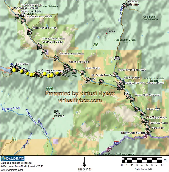
Roaring Fork Watershed Fly Fishing Public Access
Carbondale Fly Fishing Access Map
Fryingpan Fly Fishing Access Map
Upper
Lower
Upper Roaring Fork Fly Fishing Access Map
Lower Roaring Fork Fly Fishing Access Map
_________________________
Roaring Fork Valley Hatch Charts
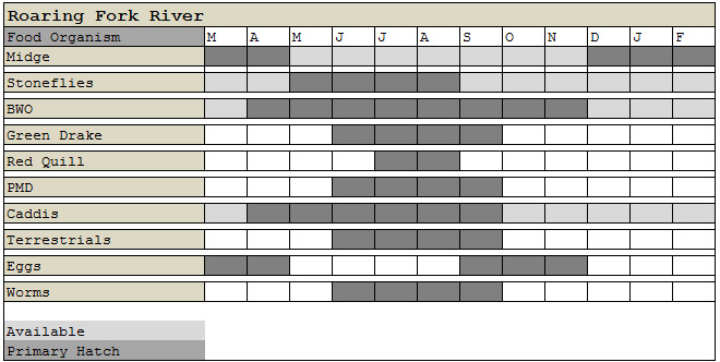
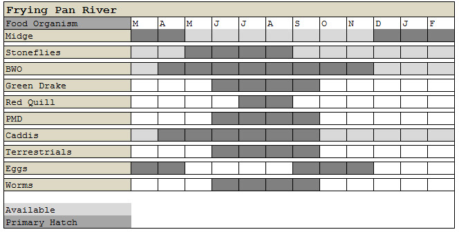
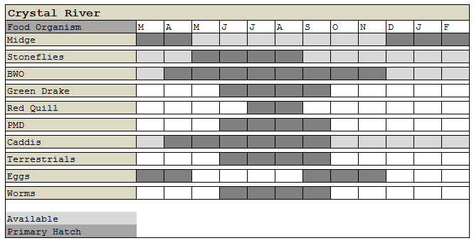
Note: These are approximations. Actual conditions may change due to weather, runoff and other natural and man-made conditions.
For more complete fishing charts organized by location on the river, season and time-of-day, including fly suggestions, images, size and entomology, download the Roaring Fork / Frying Pan iPhone fishing guide. To learn more about the application visit the Virtual FlyBox iPhone App. page.
Virtual FlyBoxRoaring Fork /Frying PanRiver![]()
Roaring Fork River Hatch Chart
Fryingpan River Hatch Chart
Crystal River Hatch Chart
_________________________
Closing Notes
The Roaring Fork Watershed is a big area. It covers 1,451 square miles which is roughly the size of Rhode Island. For fly fishermen it contains two freestone rivers, the Crystal and Roaring Fork, that are 35 miles and 70 miles in length. Additionally it contains the Fryingpan River which is a tailwater of the Reudi Reservoir.
This means that fly fishermen have two types of fly fishing rivers within close proximity and if one or two rivers are cloudy or “blown out”, there are other nearby options for finding better water.
The Roaring Fork is also a big river. Below Basalt and especially from Carbondale to Glenwood Springs, float fishing is a great way to fish the river and experience the beauty of this valley.
In addition, the Roaring Fork is a year-round fishery offering access to both Wild Trout and Gold Medal streams.
We hope you will take the opportunity to experience the amazing fishing in the Roaring Fork Valley.
See you soon …
The folks at the Virtual FlyBox